


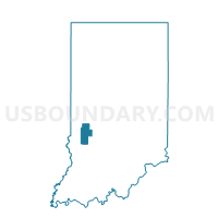
HARRISON 01, Clay County, Indiana
About
Outline

Summary
| Unique Area Identifier | 576660 |
| Name | HARRISON 01 |
| County | Clay County |
| State | Indiana |
| Area (square miles) | 13.60 |
| Land Area (square miles) | 13.59 |
| Water Area (square miles) | 0.01 |
| % of Land Area | 99.96 |
| % of Water Area | 0.04 |
| Latitude of the Internal Point | 39.30888160 |
| Longtitude of the Internal Point | -87.13693050 |
Maps


Graphs
Select a template below for downloading or customizing gragh for HARRISON 01, Clay County, Indiana


Neighbors
Neighoring Voting District (by Name) Neighboring Voting District on the Map
- HARRISON 02, Clay County, IN
- LEWIS, Clay County, IN
- PERRY, Clay County, IN
- SUGAR RIDGE, Clay County, IN
Top 10 Neighboring County Subdivision (by Population) Neighboring County Subdivision on the Map
- Harrison township, Clay County, IN (2,172)
- Lewis township, Clay County, IN (1,464)
- Sugar Ridge township, Clay County, IN (939)
- Perry township, Clay County, IN (934)